First and reprint of the Schöpfkarte
The first print of the Schöpfkarte displayed here currently exists in nine individual parts, which consist of two agglutinated sheets of paper affixed onto a release paper. Two of three text boxes are empty; the third on sheet 18 contains the text block with the old text (view on e-rara). There is no sign of a watermark, which allows the supposition that this is a first print. Currently, we know of five first prints, which are all located in Switzerland. 15 reprints (three of which are currently abroad) could be located as part of the research for the exhibition and the development of the catalogue.
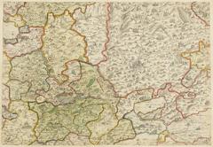
In parts, the colouration was done in a meticulous fashion, even the coats of arms in the frame and the title cartouche are colourised. According to Ryhiner, the colours of the content correspond to offices and administrative bodies. Around the city of Bern, woodlands and houses are coloured, while in the majority of the Canton only general areas and borders of administrative entities are indicated through colour. Beyond the borders of the Canton, the map does without colouration. The colours indicate the situation of the various offices after 1652, as Strättligen is assigned to the Vogtei Oberhofen, and likely before 1732, as the Landvogtei Kasteln is not yet depicted.
The 18 sheets of paper of this item belong to the collection Ryhiner and were assembled in 1934. For almost a century, the map was displayed in the Alpine Museum. In 2016, it was returned to the newly reopened Münstergasse library. After cleaning and reframing the map in 2019, it is now ready again for future display. View on E-rara.
The map exhibits grey shading of hills and mountains, subtle colouration of borders and pale red full colours to indicate the dimension of the Bernese state territory. These colourations likely stem from the 18th century. At a closer look, over twenty small yellow dots are discernible between Bern and Geneva (sheets 6, 9 to 12). They designate the distance between both cities. Furthermore, larger villages and towns are underscored with coloured pencil. Such markings indicate that the sheets of the map were used as a work instrument and contrast the aesthetic or illustrative colourations.