Subsequent maps in the 16th century
The origins of the Schöpfkarte reflect the fundamental changes after the Middle Ages, when medieval maps were replaced by new country and regional maps. It seems fitting to describe them as the incunabula of card printing.
The Schöpfkarte with its scale and its innovative comprehensive exposition of the former state territory of Bern right out offered itself to copycats. Hereafter, we present a number of maps, which are evidently related to the Schöpfkarte.
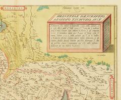
The precursor to the Schöpfkarte: A map of Switzerland in its entirety by Aegidius Tschudi was first printed in 1538 and served as a template for many mapmakers. This image shows an example from the atlas of Abraham Ortelius.
Tschudi’s map of Switzerland reflects the growing self- and national confidence of Switzerland as well as the emerging need for concrete depiction. It developed from the first maps recording individual places and regions of Switzerland, the Schöpfkarte being one of those. View on E-rara.
Willhelm Techtermann used the Schöpfkarte as a template for his own map, which he published in the same year: the first map of the Canton Fribourg. He did not manufacture it on official orders, but rather for himself. The territory outside of the Canton is an olive colour, which gives the illusion of the Canton Fribourg as an island. The map assumes much of Schöpf, but it also contains some corrections.

This map shows Wiflisburg (modern-day Avenches) depicted on a map by Gerhard Mercator. Despite being based on Schöpf, it is directed to the north. Mercator was the first to adapt Schöpf’s map for his own regional maps of Wiflisburgerau and Aarau (here with additional information from the Zürcherkarte by Jost Murer). Both of these maps were published in the Mercator-Atlas in 1585. View on e-rara.
Mercators overall maps of Switzerland changed the depiction of the country in maps. If ever available, he used regional maps such as the Schöpfkarte as templates. The north-oriented overall map of Switzerland was first published in 1585. The map depicted here is from 1630.
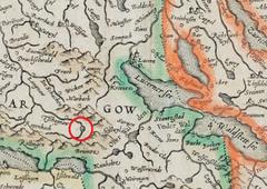
The water network was an important element of earlier small-scale maps. When the Schöpfkarte was copied, the gorge of the river Emme “Wilde Bockten” was misinterpreted and many of the subsequent maps – the present map being a good example – show a non-existing lake. View on E-rara.